Jameson Lake, Carpinteria Christmas Bird Count, 2018-01-05So, if…

Friday, February 23rd, 2018

Jameson Lake, Carpinteria Christmas Bird Count, 2018-01-05

So, if you’ve followed me for a while you know I get really into the bird thing late in the year when the Christmas Count comes around. This past year I got super into it, helping Rob (the founder of our local Christmas Count) organize things, which mostly meant letting him do the hard work of contacting everyone and lining up participants while I did the fun part: scouting (i.e., birdwatching).

We were in the home stretch when a slight hiccup occurred: The Thomas Fire. It burned through the majority of our count circle, forced evacuations of large parts of the Carpinteria Valley, and kept those who stayed behind indoors due to the horrible air quality. We basically had no choice but to postpone the count to Friday, January 5, the last day of the count window.

By the time the rescheduled count rolled around the fire was contained and people were getting their lives back together. The firefighters had done a great job, keeping the fire mostly out of the human-inhabited coastal strip. But inland it had burned unchecked.

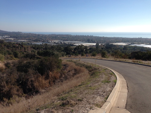
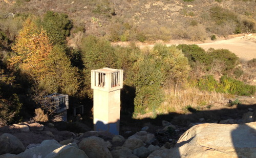
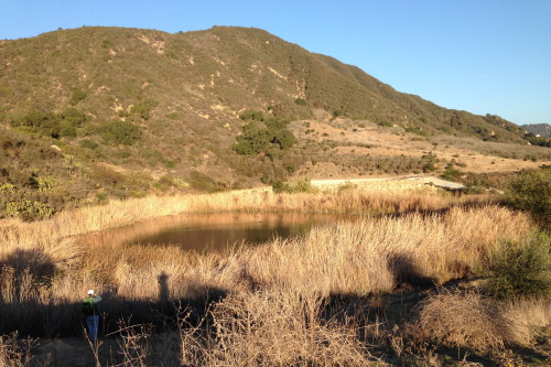
We normally work hard to get a team to Jameson Lake, a freshwater reservoir in the northern part of our circle. It’s hard to reach even in the best of times, but it’s worth it; there are birds there we just can’t get on the coast. But this year it was completely inaccessible; no one was being allowed in except firefighters and Forest Service personnel.

Then we got a break: Alan, the dam caretaker at Jameson Lake for the Montecito Water District, is a birder. He’d arranged for us to go in back in November, before the fire, for a scouting visit. Now he’d started going back in for damage assessment, and he scheduled ones of his visits for count day. Even better, he pulled some strings and got permission for a carload of us to go in with him.

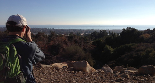
So it was that I, along with two other volunteers (Deborah and Taylor, aka @quickthreebeers) got to spend count day out of cellphone range, exploring a burned-out landscape that was eerily silent: no other people, and very few birds.

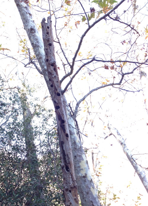
For the most part it wasn’t great birding. But it was a fascinating look at the aftermath of the fire. And in terms of the citizen-science mission of the Christmas Count, it was a wonderful opportunity to gather data on which birds were there (ducks, woodpeckers, and SO many Dark-eyed Juncoes) and which were gone. I’m really looking forward to going back over the next few years to see the area come back to life.

As I mentioned, we were out of cellphone range all day, so it was only after making the three-hour trip back at the end of the day that I was able to touch base with Rob, and get the good news about the overall count: It went great. We got 155 species, just 3 short of our all-time record.

This is some video I shot of our trip to the lake.

Reposted from http://lies.tumblr.com/post/171217768486.

Photo

Friday, December 8th, 2017

Reposted from http://ift.tt/2BOFABp.

Twitter

Friday, December 8th, 2017

Twitter:

In which I go on (and on) about the botched-and-then-corrected evacuation orders issued in Carpinteria last night. If, you know, that’s the kind of thing you’re into.

Reposted from http://ift.tt/2B38bGw.

Today has been a day of fire and ash. We’re still here, watching…

Thursday, December 7th, 2017

Today has been a day of fire and ash. We’re still here, watching the wind and waiting to see if we’ll need to evacuate.

There are two arms of the Thomas Fire pushing toward Carpinteria. One arm is coming up the coast from where it tried to burn La Conchita in the wee hours this morning. It’s about 3 miles away, but the fire crews have kept it at bay all day. The other arm is coming through the backcountry north and west of Ojai. It has farther to go to reach us, but fewer firefighters and roads in its way.

You can follow me on Twitter (where I’m @jbc99) if you want to be spammed with the latest updates.

Reposted from http://ift.tt/2ky6TMQ.

Northern mockingbird (Mimus polyglottos), photo by Wikipedia…

Wednesday, September 6th, 2017

Northern mockingbird (Mimus polyglottos), photo by Wikipedia user Captain-tucker

I’m helping to organize our local Christmas Bird Count this year, and as part of that I’ve created a page listing upcoming classes and bird walks. If you live in or around Carpinteria, California and want to participate either in the pre-count fun or the count itself (which will take place Saturday, December 16, 2017), check it out!

Reposted from http://ift.tt/2vNFIm2.

The fourth and final video in my series on sea level rise in…

Sunday, August 13th, 2017

The fourth and final video in my series on sea level rise in Carpinteria.

If you want to watch all four videos from the beginning, start here.

Reposted from http://ift.tt/2w3p6G3.

I made another video about sea level rise in Carpinteria. This…

Monday, May 22nd, 2017

I made another video about sea level rise in Carpinteria. This one looks at what we can do about it.

Reposted from http://ift.tt/2rtNGOx.

My latest video on sea level rise in Carpinteria is up now. I…

Thursday, March 23rd, 2017

My latest video on sea level rise in Carpinteria is up now. I had fun making it.

If you’re a fan of Yulin/Zack/Sean/Mary Kate’s beautiful video of Auden’s “As I Walked Out One Evening”, you’ll recognize where I got my inspiration.

Reposted from http://ift.tt/2ngx75I.

lies: My interest in the natural world has followed an odd…

Friday, March 10th, 2017

lies:

My interest in the natural world has followed an odd sequence.

At first I was drawn to birds. Then it was the insects the birds were eating, then the plants depended on by the insects.

Now it’s the earth beneath the plants.

Phase II of the Franklin Trail behind Carpinteria is now open, and today Linda and I took Rory on a hike to check it out. There was lots of cool stuff to see; a higher vantage point to view the valley, trees with colorful poison oak beneath them, a big sycamore with bear claw marks leading up its trunk.

But the most interesting thing for me was the geology along the trail. The large image above shows (I think) the transition between the Sespe Formation (on the left), with reddish sandstone and conglomerate, and the Coldwater Formation’s lighter-colored sandstone on the right.

The boundary dates to about 40 million years ago. The younger rock is on the left, the older on the right. The layers were laid down in the vicinity of present-day San Diego; since then a big chunk of land has rotated clockwise, bringing the rocks to their present location in south Santa Barbara County. In the last 2.5 million years they’ve been tilted, such that what originally were horizontal layers are now angled up at a 60-degree angle.

The Coldwater sandstone was laid down at the bottom of a shallow coastal sea. Toward the end of that process, as the world’s climate transitioned from being very much warmer than today to being as cool or cooler than today, sea levels fell dramatically, and the rocks in that photo went from being underwater to being part of a low-lying coastal plain. Periodic river flooding produced the rounded pebbles embedded in the reddish Sespe conglomerate.

It’s cool to be able to read that history in the rocks. I’m just a baby at geology, but I’m looking forward to learning more.

Reposted from http://ift.tt/2maZJKm.

I made a video (the first in a series of videos, hopefully)…

Monday, March 6th, 2017

I made a video (the first in a series of videos, hopefully) about sea level rise in Carpinteria, where I live. This one is about vulnerability.

Warning: Includes my face. 😜

Reposted from http://ift.tt/2mXoJ90.

The sky keeps trying to distract me when I’m playing…

Saturday, November 26th, 2016

The sky keeps trying to distract me when I’m playing pokemon.

Reposted from http://ift.tt/2gugnS0.

I live here

Friday, April 29th, 2016

I live here

Reposted from http://ift.tt/24qwBPS.

Layers

Friday, April 29th, 2016

Layers

Reposted from http://ift.tt/1TB2AaN.

East and West

Friday, April 29th, 2016

East and West

Reposted from http://ift.tt/24ajdCH.

Coldwater Formation

Friday, April 29th, 2016

Coldwater Formation

Reposted from http://ift.tt/1pPw7TG.

Made some new friends on my hike last Sunday.

Friday, April 29th, 2016

Made some new friends on my hike last Sunday.

Reposted from http://ift.tt/1TAkTx0.

My interest in the natural world has followed an odd sequence.At…

Monday, May 25th, 2015

My interest in the natural world has followed an odd sequence.

At first I was drawn to birds. Then it was the insects the birds were eating, and then the plants depended on by the insects.

Now it’s rocks.

Phase II of the Franklin Trail behind Carpinteria is now open, and today Linda and I took Rory on a hike to check it out. There was lots of cool stuff to see; a higher vantage point to view the valley, trees with colorful poison oak beneath them, a big sycamore with bear claw marks leading up its trunk.

But the most interesting thing for me was the geology along the trail. The large image above shows (I think) the transition between the Sespe Formation (on the left), with reddish sandstone and conglomerate, and the Coldwater Formation’s yellow sandstone on the right.

The boundary dates to about 40 million years ago. The Coldwater sandstone is older, the Sespe conglomerate younger. The layers were laid down in the vicinity of present-day San Diego; since then a big chunk of land has rotated clockwise, bringing the rocks to their present location in south Santa Barbara County. In the last 2.5 million years they’ve been tilted up, such that what originally were horizontal layers are now angled up at a 60-degree angle.

The Coldwater sandstone was laid down at the bottom of a shallow coastal sea. Toward the end of that process, as the world’s climate transitioned from being very much warmer than today to being as cool or cooler than today, sea levels fell dramatically, and the rocks in that photo went from being underwater to being part of a low-lying coastal plain. Wave action in the surf zone (maybe?) or periodic river flooding produced the rounded pebbles embedded in the reddish Sespe conglomerate.

It’s cool to be able to read that history in the rocks. I’m just a baby at geology, but I’m looking forward to learning more.

Reposted from http://ift.tt/1FRZ7kV.

Photos from our afternoon hike into Rancho Monte Alegre for the…

Saturday, December 21st, 2013

Photos from our afternoon hike into Rancho Monte Alegre for the Carpinteria Christmas Bird Count on December 20, 2013.

View of Carp from RMA – Rancho Monte Alegre is a former ranch that is being developed with a small number of super-expensive hilltop estates. (I guess the brochure probably doesn’t describe them exactly like that, but that’s what they are.) It’s behind a locked gate, but they’ve been nice enough to let us enter the property each year for the Christmas Count.

I like this first photo because you get a really nice view of Carpinteria, where I live. There’s the city itself along the ocean, then a row of greenhouses that are used for flower-growing (mostly), then a belt of avocado orchards and ranch houses, leading up to the chaparral where the photo was taken.

Carp from the Santa Monica Creek debris dam – Santa Barbara County flood control (I assume) has done a bunch of work on Santa Monica Creek, including building a big dam of boulders across the creekbed. The idea, I think, is that in the event of a major mud/debris flood, all that stuff would be caught by the dam so it wouldn’t destroy the housing downstream. As someone who lives in one of those houses I appreciate the sentiment, though I kind of wish the flood control work (which happened in the early 1970s) had given a little more thought to the habitat values of the creek. Especially in the lower portion, the channelization of the creek to make it a more efficient water-conveying device also served to make it essentially unusable by migrating steelhead trout, which is a real shame given the great steelhead habitat in the upper creek. It also sacrificed a lot of prime riparian habitat along the lower creek.

Anyway, here we are standing on the debris dam looking south across some of the big trees that remain in the upper reaches of the creek. That’s Frederic, one of the awesome citizen scientists who joined me for the afternoon outing.

Standing snag – Down in that riparian habitat that you can see in the previous picture is this sycamore snag. I don’t know which woodpeckers nested in it (Nuttall’s, maybe?) but clearly there were many years’ worth of nest holes hollowed out in that trunk.

Flood control inlets – This is a really interesting part of the flood control feature on the creek. We’re standing on the same debris dam as in photo #2, but this time looking north into the catch basin. There are three different boxy structures at different heights; each one contains a giant culvert that leads under the dam. The idea, I assume, is that in a flooding event water will collect behind the dam, and as it rises it will begin to drain through one, then two, and finally through all three of the culverts. You can’t see it in this photo, but there was a pool of water at the level of the lowest culvert, and from atop the dam we could hear the water trickling into it.

RMA cattle pond – This artificial pond was our main objective for the Christmas count, because it’s one of the few places in our count circle that reliably produces sightings (or more properly, hearings) of Sora, a shy rail that likes to hide in cattails. We tried clapping next to the reeds (which can startle Soras into vocalizing), but had no luck. Later, though, on our way out, we stopped by the pond one more time, and Wayne, one of our group, played a recorded Sora call — and a Sora responded! Yay!

The full list of bird species recorded by our group is in this post.

Reposted from http://lies.tumblr.com/post/70720254085.